Alderga and Aldergamouth: Difference between revisions
replaced old intro text by fact list |
chapter links |
||
| (18 intermediate revisions by the same user not shown) | |||
| Line 1: | Line 1: | ||
'''Aldergamouth was a port:''' | |||
'''Aldergamouth was a | |||
* located three poles, or a half tide, south of [[Medeasblik]] (8a) | * located three poles, or a half tide (c. 3 hours?), south of [[Medeasblik]] (8a) | ||
* where former sea king [[Sterik]] (uncle of sea warriors [[Tunis]] and [[Inka]]) had taken his retirement (8b) | * where former sea king [[Sterik]] (uncle of sea warriors [[Tunis]] and [[Inka]]) had taken his retirement (8b) | ||
* at the southern head of which stood the [[Treasureburg]], a stone building where a variety of shells, horns, weapons, and clothes were kept, brought home from distant lands by the steersmen (13i) | * at the southern head of which stood the [[Treasureburg]], a stone building where a variety of shells, horns, weapons, and clothes were kept, brought home from distant lands by the steersmen (13i) | ||
| Line 8: | Line 7: | ||
'''Alderga was a lake:''' | '''Alderga was a lake:''' | ||
* located a quarter of | * located a quarter (<span class="fryas">FJARDÉL</span>, of a day?) from the Aldergamouth (13i); | ||
* surrounded by richly ornamented barns, houses, and gardens (13i); | * surrounded by richly ornamented barns, houses, and gardens (13i); | ||
* in which an operational fleet was docked, with flags of many colors (13i); | * in which an operational fleet was docked, with flags of many colors (13i); | ||
* connected to a narrow mouth (ÉGA | * connected to a narrow (?) mouth (<span class="fryas">ÉGA MVDA</span>) into the sea by a dug canal, which flowed past the burg [[Forana]]. This canal was the way out for the fleet, and the [[Flee]] was the way in (through the Aldergamouth). On both sides of the canal were beautiful houses, brightly colored, with gardens surrounded by evergreen hedges (13i). This canal was blocked by sand and lost due to the big flood of ca. 305 BCE (14a); | ||
* where poor [[Saxmen]] came with their wives to search in the soil for golden and other jewelry after the big flood of ca. 305 BCE (14b); | * where poor [[Saxmen]] came with their wives to search in the soil for golden and other jewelry after the big flood of ca. 305 BCE (14b); | ||
* where some of the [[Ionians]] settled, as they believed themselves to have sprung from the folk of the Alderga (14c); | * where some of the [[Ionians]] settled, as they believed themselves to have sprung from the folk of the Alderga (14c); | ||
| Line 17: | Line 16: | ||
* which was the final destination of the journeys of both [[Apollania]] (13i/16d) and [[Adel "Atharik"|Adel]] and [[Ifkia]] (16d). | * which was the final destination of the journeys of both [[Apollania]] (13i/16d) and [[Adel "Atharik"|Adel]] and [[Ifkia]] (16d). | ||
* on the shore of which sea king [[Jon]] was born (9b); | * on the shore of which sea king [[Jon]] was born (9b); | ||
<span class="fryas">[[ALDER-]]</span> means 'of all' (Dutch: 'aller') and <span class="fryas">[https://fryskednis.blogspot.com/2019/05/auxiliary-verbs-ga-leta-kunna.html GÁ]</span> means 'to go', so the name may suggest that the water was a passage for all ships from the Flee Lake to Wralda's Sea. | |||
== Fragments == | == Fragments == | ||
[[ | [[EN050.19 Magyars|'''K1-50.19''' Magyars and Finns]] | ||
[<nowiki/>[[050|050/19]]] | :[<nowiki/>[[050|050/19]]] The following is inscribed on the Treasureburg at the '''Aldergamouth''' (<span class="fryas">ALDE.GÁ.MVDE</span>): (...) It is located three poles, or a half tide, south of Medeasblik. | ||
'' | [[EN053.12 Wodin|'''K2-53.12''' Wodin and the Magus]] | ||
[[ | :[<nowiki/>[[053|053/15]]] At the '''Aldergamouth''' (<span class="fryas">ALDER.GÁ.MVDE</span>), a former sea king had taken his retirement. Sterik was his name, and the renown of his deeds was great. (...) Tunis and Inka were sea warriors and, at the time, they were staying in the home of their father’s brother at the '''Aldergamouth''' (<span class="fryas">ALDER.GÁ.MVDE</span>). | ||
[ | [[EN065.15 Jon|'''L1-65.15''' Jon’s Revenge]] | ||
:[<nowiki/>[[065|065/20]]] Jon — meaning: ‘given’ — was a sea king, born at the '''Alderga''' (<span class="fryas">ALDER.GÁ</span>), who had sailed out of the Flee Lake with a hundred and twenty-seven ships | |||
[[ | [[EN085.12 Medeasblik|'''N2-85.12''' Death of the Magus]] | ||
[<nowiki/>[[ | :[<nowiki/>[[085|085/20]]] The steersmen of Staveren and of the '''Alderga''' (<span class="fryas">ALDERGA</span>) were eager to confront him, but the great fleet was out on a distant voyage. | ||
'' | [[EN108.28 Rhine|'''R6-108.28''' Apollania’s Journey]] | ||
[[ | :[<nowiki/>[[110|110/15]]] Finally, we arrived at the '''Alderga[-mouth]''' (<span class="fryas">ALDERGA</span>). At the southern head of the harbor stands the Treasureburg, a stone building where a variety of shells, horns, weapons, and clothes are kept, brought home from distant lands by the steersmen. A quarter of a day from there is the '''Alderga''' (<span class="fryas">ALDERGA</span>), a great lake surrounded by barns, houses, and gardens — all richly ornamented. In the lake, a great fleet lay ready, with flags of many colors. (...) Behind the lake, a canal had been dug, which flowed past the burg Forana, and further through a narrow mouth into the sea. This was the way out for the fleet, and the Flee was the way in. On both sides of the canal are beautiful houses, brightly colored, with gardens surrounded by evergreen hedges. | ||
[ | [[EN113.23 Grievances|'''S1-113.23''' Fryasland Swamped]] | ||
:[<nowiki/>[[116|116/30]]] The canal that had run across the land from the '''Alderga''' (<span class="fryas">ALDERGÁ</span>) had been blocked by sand and was lost. | |||
[[ | [[EN117.20 Blacks|'''S1-117.20''' Gosa: Settlement of the Black Men]] | ||
[<nowiki/>[[ | :[<nowiki/>[[118|118/20]]] When our lands were passable again, groups of poor Saxmen came with their wives to the regions of Staveren and the '''Alderga''' (<span class="fryas">ALDERGA</span>) to search for golden and other jewelry in the sodden soil. | ||
'' | [[EN118.32 Fleet|'''S2-118.32''' A Fleet Arrives]] | ||
[[ | :[<nowiki/>[[120|120/01]]] Some of the Ionians who believed themselves to have sprung from the folk of the '''Alderga''' (<span class="fryas">ALDERGA</span>) went there. | ||
[ | [[EN144.17 Motherless|'''U2-144.17''' Friso: Alliances]] | ||
:[<nowiki/>[[148|148/10]]] because at Staveren and along the '''Alderga''' (<span class="fryas">ALDER.GÁ</span>) the best warships are built of hard oak which never rots. | |||
[[ | [[EN154.17 Adel|'''U3-154.17''' Adel and Ifkia]] | ||
[<nowiki/>[[ | :[<nowiki/>[[157|157/20]]] Just like Apollania, they concluded their journey with a visit to Lydasburg and the '''Alderga''' (<span class="fryas">ALDER.GÁ</span>). | ||
== Interpretations == | |||
[ | Ottema translated as 'Alderga' and 'Alde(r)gamude'. He did not speculate about where they may have been located, neither in a foortone, nor in “[http://aldfryas.blogspot.com/2020/02/historical-notes-and-clarifications-to.html Geschiedkundige Aantekeningen en Ophelderingen]” (1878). | ||
Overwijn translated as 'Alde(r)ga' and 'Aldegamond(e)'. To the fragment of ch. 8a he noted in his 1941 edition (p.53): "[[wikipedia:Oudorp|Ouddorp]] (Alderga) near Alkmaar". | |||
'' | Jensma translated as 'Oudegouw' and 'Oudegouwemond' and located both at [[wikipedia:Enkhuizen|Enkhuizen]]. This is remarkable, since fragment 13i states that they were separated by a quarter of a day (?) (<span class="fryas">FJARDÉL</span>). Also, fragment 8a states that Aldergamouth was located three poles, or a half tide (3 hours?) south of Medeasblik, whereas Enkuizen is rather (south-) eastward of Medemblik (assuming the latter is located where once Medeasblik was). | ||
[[ | Initially translating <span class="fryas">FJARDÉL</span> as 'quarter of an hour', at later consideration (25-3-2023) Ott thinks that it will rather have been a quarter of a day or of twenty-four hours. His provisional interpretation is that the Aldergamouth with its [[Treasureburg]] must have been located approximately between what are now [https://nl.wikipedia.org/wiki/Hoorn_(Noord-Holland) Hoorn] and [https://nl.wikipedia.org/wiki/Wijdenes Wijdenes]; that lake Alderga will have been approximately where later the [https://nl.wikipedia.org/wiki/Waert Waerdt] (now Heerhugowaard) or the [https://nl.wikipedia.org/wiki/Schermer_(droogmakerij) Schermer] (or the [https://nl.wikipedia.org/wiki/Wogmeer Wogmeer]?) was. The canal from Alderga, along Forana, to the sea will partly correspond to the Pettemer Vaert (also see [https://www.molend.nl/hoornse-vaart.html Hoornse Vaart]). | ||
[ | If Alderga was (what later was) [[wikipedia:IJ_(Amsterdam)|the IJ]] (on 16th century map ''Tie'', i.e. ''<nowiki/>'t Ie'' on in Fryas <span class="fryas">T.É</span> - 'the water'), then the Noordzee canal connecting the IJ to the new IJmuiden (IJ-mouth) opened in 1876, was an earlier version of the canal from Forana to the 'narrow mouth' (<span class="fryas">ÉNGA MVDA</span>) into the sea. Aldergamude could then have been where now Muiden is (or Amsterdam?), [[Forana, Vronen|Forana]] may then have been where now [[wikipedia:Beverwijk|Beverwijk]] (or Haarlem?) is and lake [[Alkmarum|Al(i)kmarum]] may then have been the [[wikipedia:Haarlemmermeer|Haarlemmermeer]]. | ||
'' | == Westfrisian '(Oude) Gouw(e)' toponyms == | ||
[[ | Although <span class="fryas">[[ALDER-]]</span> does not seem to mean 'old(er)' but rather 'of all' (Dutch: 'aller'), it may be tempting to relate it to 'Oude Gouw', as Jensma translated it. The modern name may have been the result of confusion, as the old name was remembered, but its original meaning forgotten. | ||
''Soo en moet niemant ladiken (vuil baggeren) in enighe sloten .., uutghenomen die tocht, die '''oude gou''' ende andere ghemeene wateren'', Wfri. Stadr. 2, 222, 158, Holland, 1520-1530 | ''Soo en moet niemant ladiken (vuil baggeren) in enighe sloten .., uutghenomen die tocht, die '''oude gou''' ende andere ghemeene wateren'', Wfri. Stadr. 2, 222, 158, Holland, 1520-1530 | ||
''So moet daer niemant scuitwasen in halighen slooten twischen die (een woord uit?) ende die '''oude ghou''' op een pont'', 262, 127. | ''So moet daer niemant scuitwasen in halighen slooten twischen die (een woord uit?) ende die '''oude ghou''' op een pont'', 262, 127. | ||
See map ''Waters with "Gouw" names'' below. | |||
(add sources) | (add sources) | ||
== Maps of the area == | == Maps of the area == | ||
to be | <gallery> | ||
File:WF rec 13th century Gouwe marked.jpg|Waters with "Gouw" names in reconstructed map of 13th century Westfriesland. | |||
File:4 maps alderga area.jpg|Westfriesland: reconstucted map of 1300 and three 16th century maps. | |||
File:Bodem alderga gebied.jpg|Geological map, map with reconstruction of peat rivers c. 800 CE and combination of the two. | |||
File:Oude sluis Schellinkhout.jpg|Reconstruction of Drecht mouth at Schellinkhout. The current ''Dorpsstraat'' used to be called ''De Gouw''. | |||
File:Schellinkhout area.jpg|Schellinkhout satellite image | |||
</gallery> | |||
== Sources == | |||
* "Onstaan, Ontginning en bemaling van West-Friesland" (Arie Bijman, 2019). | |||
* "Een 16 de -eeuwse stolpboerderij op een middeleeuwse terp" (West-Friese Archeologische Rapporten 108, 2017 [https://collectie.huisvanhilde.nl/pdf/WAR_108_Schellinkhout_Dorpsweg67.pdf PDF]) | |||
[[Category:Places]] | |||
[[Category:Location Studies]] | |||
Latest revision as of 07:01, 24 August 2024
Aldergamouth was a port:
- located three poles, or a half tide (c. 3 hours?), south of Medeasblik (8a)
- where former sea king Sterik (uncle of sea warriors Tunis and Inka) had taken his retirement (8b)
- at the southern head of which stood the Treasureburg, a stone building where a variety of shells, horns, weapons, and clothes were kept, brought home from distant lands by the steersmen (13i)
Alderga was a lake:
- located a quarter (FJARDÉL, of a day?) from the Aldergamouth (13i);
- surrounded by richly ornamented barns, houses, and gardens (13i);
- in which an operational fleet was docked, with flags of many colors (13i);
- connected to a narrow (?) mouth (ÉGA MVDA) into the sea by a dug canal, which flowed past the burg Forana. This canal was the way out for the fleet, and the Flee was the way in (through the Aldergamouth). On both sides of the canal were beautiful houses, brightly colored, with gardens surrounded by evergreen hedges (13i). This canal was blocked by sand and lost due to the big flood of ca. 305 BCE (14a);
- where poor Saxmen came with their wives to search in the soil for golden and other jewelry after the big flood of ca. 305 BCE (14b);
- where some of the Ionians settled, as they believed themselves to have sprung from the folk of the Alderga (14c);
- where the best warships were built of hard oak which never rots (16b);
- which was the final destination of the journeys of both Apollania (13i/16d) and Adel and Ifkia (16d).
- on the shore of which sea king Jon was born (9b);
ALDER- means 'of all' (Dutch: 'aller') and GÁ means 'to go', so the name may suggest that the water was a passage for all ships from the Flee Lake to Wralda's Sea.
Fragments
- [050/19] The following is inscribed on the Treasureburg at the Aldergamouth (ALDE.GÁ.MVDE): (...) It is located three poles, or a half tide, south of Medeasblik.
- [053/15] At the Aldergamouth (ALDER.GÁ.MVDE), a former sea king had taken his retirement. Sterik was his name, and the renown of his deeds was great. (...) Tunis and Inka were sea warriors and, at the time, they were staying in the home of their father’s brother at the Aldergamouth (ALDER.GÁ.MVDE).
- [065/20] Jon — meaning: ‘given’ — was a sea king, born at the Alderga (ALDER.GÁ), who had sailed out of the Flee Lake with a hundred and twenty-seven ships
- [085/20] The steersmen of Staveren and of the Alderga (ALDERGA) were eager to confront him, but the great fleet was out on a distant voyage.
- [110/15] Finally, we arrived at the Alderga[-mouth] (ALDERGA). At the southern head of the harbor stands the Treasureburg, a stone building where a variety of shells, horns, weapons, and clothes are kept, brought home from distant lands by the steersmen. A quarter of a day from there is the Alderga (ALDERGA), a great lake surrounded by barns, houses, and gardens — all richly ornamented. In the lake, a great fleet lay ready, with flags of many colors. (...) Behind the lake, a canal had been dug, which flowed past the burg Forana, and further through a narrow mouth into the sea. This was the way out for the fleet, and the Flee was the way in. On both sides of the canal are beautiful houses, brightly colored, with gardens surrounded by evergreen hedges.
- [116/30] The canal that had run across the land from the Alderga (ALDERGÁ) had been blocked by sand and was lost.
S1-117.20 Gosa: Settlement of the Black Men
- [118/20] When our lands were passable again, groups of poor Saxmen came with their wives to the regions of Staveren and the Alderga (ALDERGA) to search for golden and other jewelry in the sodden soil.
- [120/01] Some of the Ionians who believed themselves to have sprung from the folk of the Alderga (ALDERGA) went there.
- [148/10] because at Staveren and along the Alderga (ALDER.GÁ) the best warships are built of hard oak which never rots.
- [157/20] Just like Apollania, they concluded their journey with a visit to Lydasburg and the Alderga (ALDER.GÁ).
Interpretations
Ottema translated as 'Alderga' and 'Alde(r)gamude'. He did not speculate about where they may have been located, neither in a foortone, nor in “Geschiedkundige Aantekeningen en Ophelderingen” (1878).
Overwijn translated as 'Alde(r)ga' and 'Aldegamond(e)'. To the fragment of ch. 8a he noted in his 1941 edition (p.53): "Ouddorp (Alderga) near Alkmaar".
Jensma translated as 'Oudegouw' and 'Oudegouwemond' and located both at Enkhuizen. This is remarkable, since fragment 13i states that they were separated by a quarter of a day (?) (FJARDÉL). Also, fragment 8a states that Aldergamouth was located three poles, or a half tide (3 hours?) south of Medeasblik, whereas Enkuizen is rather (south-) eastward of Medemblik (assuming the latter is located where once Medeasblik was).
Initially translating FJARDÉL as 'quarter of an hour', at later consideration (25-3-2023) Ott thinks that it will rather have been a quarter of a day or of twenty-four hours. His provisional interpretation is that the Aldergamouth with its Treasureburg must have been located approximately between what are now Hoorn and Wijdenes; that lake Alderga will have been approximately where later the Waerdt (now Heerhugowaard) or the Schermer (or the Wogmeer?) was. The canal from Alderga, along Forana, to the sea will partly correspond to the Pettemer Vaert (also see Hoornse Vaart).
If Alderga was (what later was) the IJ (on 16th century map Tie, i.e. 't Ie on in Fryas T.É - 'the water'), then the Noordzee canal connecting the IJ to the new IJmuiden (IJ-mouth) opened in 1876, was an earlier version of the canal from Forana to the 'narrow mouth' (ÉNGA MVDA) into the sea. Aldergamude could then have been where now Muiden is (or Amsterdam?), Forana may then have been where now Beverwijk (or Haarlem?) is and lake Al(i)kmarum may then have been the Haarlemmermeer.
Westfrisian '(Oude) Gouw(e)' toponyms
Although ALDER- does not seem to mean 'old(er)' but rather 'of all' (Dutch: 'aller'), it may be tempting to relate it to 'Oude Gouw', as Jensma translated it. The modern name may have been the result of confusion, as the old name was remembered, but its original meaning forgotten.
Soo en moet niemant ladiken (vuil baggeren) in enighe sloten .., uutghenomen die tocht, die oude gou ende andere ghemeene wateren, Wfri. Stadr. 2, 222, 158, Holland, 1520-1530
So moet daer niemant scuitwasen in halighen slooten twischen die (een woord uit?) ende die oude ghou op een pont, 262, 127.
See map Waters with "Gouw" names below.
(add sources)
Maps of the area
-
 Waters with "Gouw" names in reconstructed map of 13th century Westfriesland.
 -
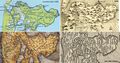 Westfriesland: reconstucted map of 1300 and three 16th century maps.
 -
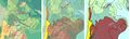 Geological map, map with reconstruction of peat rivers c. 800 CE and combination of the two.
 -
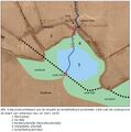 Reconstruction of Drecht mouth at Schellinkhout. The current Dorpsstraat used to be called De Gouw.
 -
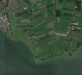 Schellinkhout satellite image


Sources
- "Onstaan, Ontginning en bemaling van West-Friesland" (Arie Bijman, 2019).
- "Een 16 de -eeuwse stolpboerderij op een middeleeuwse terp" (West-Friese Archeologische Rapporten 108, 2017 PDF)